
Which regions in Türkiye are at risk of tsunami?

According to the Kandilli Observatory, more than 90 tsunamis have occurred in Türkiye over the last three thousand years, primarily in the Sea of Marmara, and along all coasts from the Black Sea to the Aegean.
According to UNESCO, the word is a combination of the Japanese words tsu (harbor) and nami (wave).
In addition to earthquakes, tsunamis can occur due to reasons such as underwater volcanic eruptions, landslides in the sea, and, in rare cases, meteor strikes.
Answering BBC Turkish's questions, Boğaziçi University Kandilli Observatory and Earthquake Research Institute (KRDAE) Director Prof. Dr. Nurcan Meral Özel and Regional Earthquake and Tsunami Monitoring Center Marine Sciences Coordinator Dr. Tuğçe Ergün said that Türkiye has "three main marine regions that are at risk for tsunamis due to their active tectonic structure."
The duo lists these regions as the Marmara Sea, the Aegean Sea and the Eastern Mediterranean.
“The tsunami hazard in these regions is associated with mechanisms such as fault-induced vertical displacements, submarine landslides, and shallow earthquakes near the coast,” they add.
There are studies showing that all of Türkiye's coasts, especially the Aegean, have been affected by tsunamis in recent history.
Speaking to BBC Turkish, Prof. Dr. Ahmet Cevdet Yalçıner, Head of the UNESCO Northeast Atlantic and Mediterranean Tsunami Warning System, stated that, based on historical tsunamis, a potential tsunami off the Turkish coast could create waves of "at most five to six meters," unlike Japan, where waves rise tens of meters.
So, what is known about the tsunami risk in Türkiye, and what does past tsunami data say about it? BBC Turkish asked experts.
Aegean Sea: 'Waves could reach Izmir, Aydin, Muğla within an hour'
According to the London-based Royal Geographical Society, the Aegean Sea experiences an average of more than 20,000 earthquakes a year.
Prof. Dr. Nurcan Meral Özel and Dr. Tuğçe Ergün from the Kandilli Observatory state that the Aegean Sea poses a "high tsunami hazard due to the active subduction zone and normal fault systems along the Hellenic Arc."
Subduction describes the upward and downward movements of the Earth's crustal layers due to reasons such as temperature differences.
The two experts added, "Reverse fault-induced earthquakes of magnitude 7 to 7.7 that could occur off the coast of Crete could cause tsunami waves that could reach our western coasts, such as Izmir, Aydın and Muğla, in about an hour."
They emphasize that the massive earthquake that occurred near Crete in 365 BC caused a devastating tsunami throughout the Eastern Mediterranean.
Prof. Dr. Özel and Dr. Ergün say, "Tsunami generation in this region can occur both through vertical movements on the main fault plane and through landslides."
There are records showing that the region has experienced many tsunamis until recent history.
According to the Kandilli Observatory Regional Earthquake - Tsunami Monitoring and Assessment Center, among the earthquakes that produced tsunamis in the region is the Amorgos earthquake that occurred in the Southern Aegean in 1956.
Accordingly, after the earthquake, the tsunami wave reached 1 meter in Fethiye.
Another earthquake known to have caused a tsunami is the Gökova Bay earthquake of July 21, 2017.
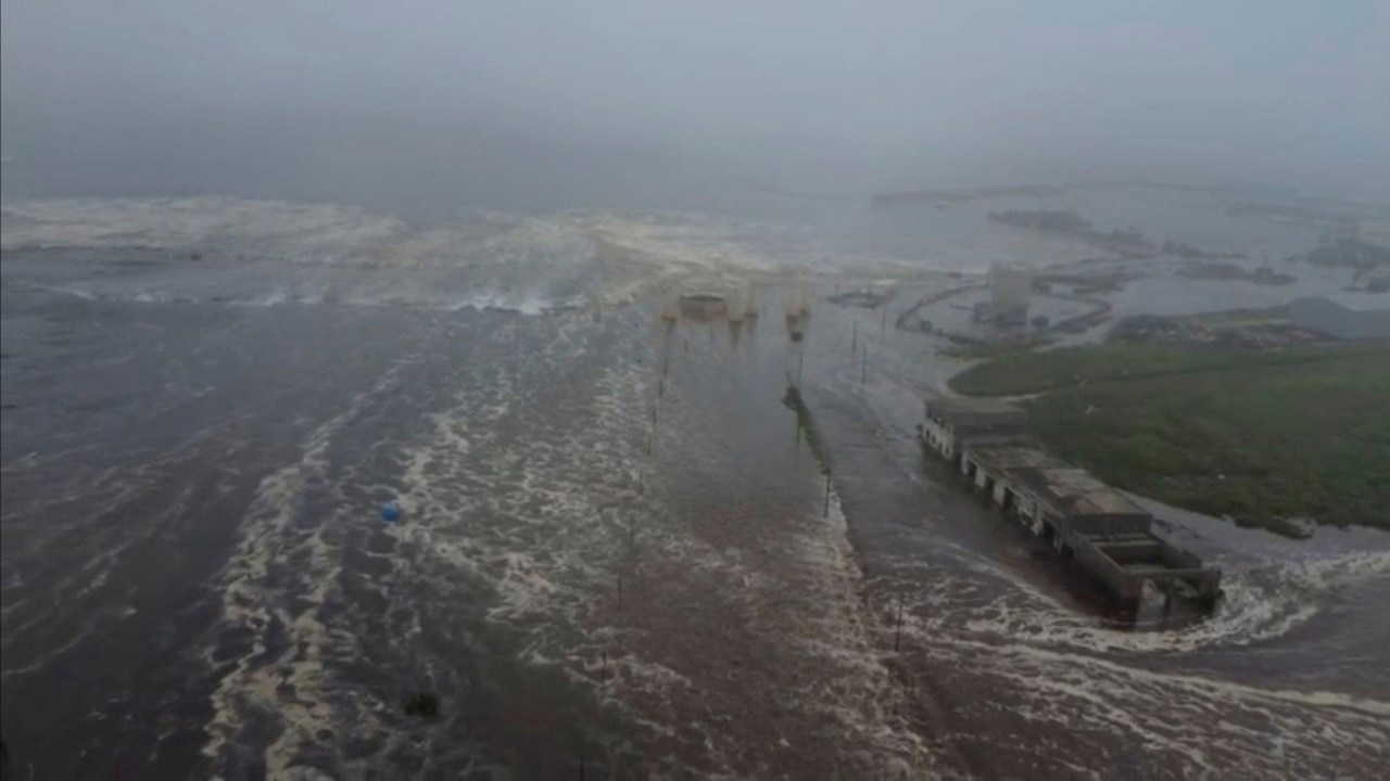
Following the 6.6 magnitude Kos Island earthquake, a wave height of 30-40 cm was observed along the Bodrum coast and partial flooding occurred due to the tsunami.
According to the center, field studies conducted in Gümbet, where vehicles were swept away, determined that the tsunami climb height was up to 1.9 meters.
The 6.9 magnitude earthquake that occurred in the Aegean Sea between the north of the island of Samos and the Doğanbey-İzmir coast on October 30, 2020, created a tsunami that was particularly effective in Seferihisar and Urla.
One person died in the Sığacık neighborhood of Seferihisar due to the tsunami, and many structures, from residences to a marina and boats, were damaged.
During the field research conducted in Sığacık Bay and its surroundings under the leadership of Prof. Dr. Ahmet Cevdet Yalçıner at that time, a tsunami run-up height of nearly 3.8 meters was determined in the Akarca area.
Prof. Dr. Ahmet Cevdet Yalçıner predicts that the expected tsunamis could have damaging effects, as they have in the past, mostly on coastal ports, cruise terminals, and coastal facilities.
However, he says it is difficult to estimate the frequency of tsunamis based on historical data.
Yalçıner says, "We know that there have been 35 tsunamis in the Marmara Sea in the last two thousand years. Tsunamis can occur in quick succession or at intervals as long as a century. Therefore, we cannot give a fixed interval for their occurrence."
Kandilli Observatory: 'Local wave heights exceeding 2 meters can be observed in the Marmara Sea'According to the information provided by Prof. Dr. Özel and Dr. Ergün, the submarine segments of the North Anatolian Fault (NAF) in the Marmara Sea pose a tsunami risk.
These are the Yalova-Çınarcık, Central Marmara and Tekirdağ segments.
The two scientists state that these segments have the potential to produce earthquakes of magnitude 7 and above.
"The fact that these segments off the coast of Istanbul are close to the surface and the fault ruptures at shallow depths poses a significant risk in terms of tsunami formation," they add.
Prof. Dr. Özel and Dr. Ergünür say that, according to numerical models made by the Kandilli Observatory, wave heights exceeding 2 meters can be observed locally in the Sea of Marmara.
In recent major earthquakes, tsunamis occurred in the Sea of Marmara.
According to the Kandilli Observatory, research has determined that the August 17, 1999 İzmit Earthquake triggered a landslide, resulting in tsunami waves reaching heights of 2.6 meters around Tütünçiftlik and Hereke, and 2.9 meters in Değirmendere.
Eastern Mediterranean: 'Earthquakes of magnitude 7 and above may generate tsunamis along the southeastern coast'A part of Türkiye's coasts that are at risk of tsunami are in the Eastern Mediterranean.
Prof. Dr. Özel and Dr. Ergünür say that the Cyprus Arc and the Levant Fault Zone in the Eastern Mediterranean have the potential to generate tsunamis off the southern coast of Türkiye.
The Levant Fault Zone extends from the Red Sea to Türkiye and is over a thousand kilometers long.
The Cyprus Arc describes the arc-shaped fault line that surrounds the southern parts of Cyprus in the easternmost part of the Mediterranean.
Two scientists warn that earthquakes of magnitude 7 or greater could cause locally impacting tsunami waves along the southeastern coast.
They also emphasize that "seismically triggered submarine landslides can also play a major role in tsunami generation."
"Early warning systems in coastal areas should be increased and risk maps should be updated."
Prof. Dr. Özel and Dr. Ergün state that the most effective mechanisms in tsunami formation are generally reverse and normal faulting.
The terms reverse and normal describe the relative movement of two plates along the fault.
"Although strike-slip faults do not directly produce large waves, especially in closed basins such as the Sea of Marmara, they can indirectly generate significant tsunami waves by triggering submarine landslides," they say.
The duo say that tsunami risk assessments should therefore be considered "not only by fault type, but also by ground morphology and landslide potential."
According to information provided by two scientists, measures taken against tsunamis in Türkiye include three main components: early warning infrastructure, physical guidance and signaling in the field, and community-based awareness/drill activities.
Kandilli Observatory and Earthquake Research Institute (KOERI) operates as an IOC/UNESCO accredited Tsunami Service Provider (TSP) carrying out tsunami monitoring, assessment and warning duties on behalf of Türkiye.
The Institute analyzes the tsunami potential after earthquakes of magnitude 5.5 and above, produces messages at information or warning levels when necessary, and transmits them to the relevant institutions.
28 sea level observation stations support these analyses by providing integrated data.
Prof. Dr. Özel and Dr. Ergün say that it will be possible to monitor the submarine more closely thanks to the eight seafloor seismometers (OBS) placed in critical segments of the North Anatolian Fault in the Marmara Sea in 2025.
An important part of the tsunami preparedness efforts covering the region including Türkiye is the UNESCO-supported international CoastWAVE Project.
This project includes efforts ranging from detection and warning to awareness-raising in Türkiye, as well as in Malta, Cyprus, Greece, Egypt, Morocco, and Spain. Governments that complete these efforts are granted "Tsunami-Ready Community" status.
Büyükçekmece district of Istanbul was chosen as the pilot area for these studies.
Prof. Dr. Özel and Dr. Ergün say that significant preparations have been made in the district, from tsunami modeling studies to planning evacuation routes, from the installation of signage and siren systems to drills with public participation.
At the end of the process, the district received "Tsunami Ready Community" status.
The two recommend increasing early warning systems in coastal areas, raising public awareness, updating tsunami risk maps, and organizing regular evacuation plans and drills.
Cumhuriyet


